Services
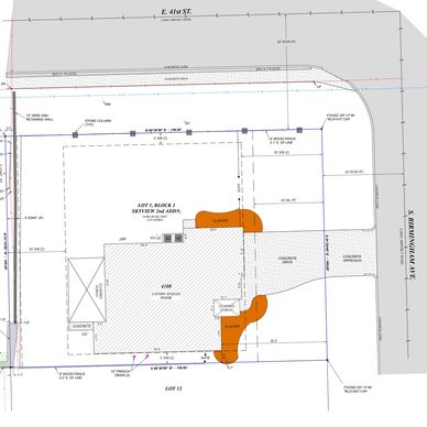
American Land and Title Association (ALTA) Title Survey
American Land and Title Association (ALTA) Title Survey
American Land and Title Association (ALTA) Title Survey
A survey of real property, including the plat of survey, acceptable to a title insurance company for purposes of insuring title to said real property, free and clear of survey questions, except those questions disclosed by the survey and indicated on the plat.
Boundary and Stake Survey
American Land and Title Association (ALTA) Title Survey
American Land and Title Association (ALTA) Title Survey
A survey performed to establish or re-establish a boundary line on the ground or to obtain data for constructing a map or plat showing a boundary line.
LIDAR Drone Scanning
American Land and Title Association (ALTA) Title Survey
LIDAR Drone Scanning

Do you have a large or heavily wooded parcel of land? This type of survey utilizes an aerial drone equipped with LIDAR technology to accurately map natural and artificial objects to provide fast, precise, and workable drawings.
Topographic Survey
Ground Based 3D Laser Scanning
LIDAR Drone Scanning
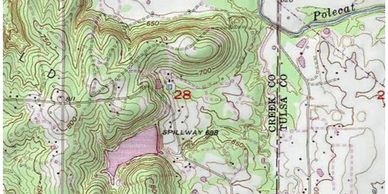
A topographic survey locates and maps each surface feature of a specific area. This includes ground contours, man-made improvements, utilities, boundary lines, and other vegetation.
Ground Based 3D Laser Scanning
Ground Based 3D Laser Scanning
Ground Based 3D Laser Scanning

A survey that captures the spatial details of an existing building or other structure using LIDAR and photogrammetry technology to provide a precise 3D product. This survey is great for building interiors and exteriors. It is especially practical for engineers, architects, and archeologists.
Subdivision Survey
Ground Based 3D Laser Scanning
Ground Based 3D Laser Scanning
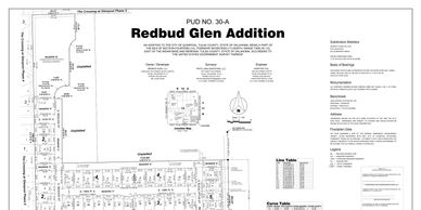
A type of land survey in which the legal boundaries of an area are located and the area is divided into parcels of lots, streets, right-of-way and other accessories. All necessary corners or dividing lines are marked or monumented.
Site Planning and Design Survey
Site Planning and Design Survey
Site Planning and Design Survey

A combination of boundary and topographic surveys with the resulting information being used for designing development features such as roads, subdivisions, utilities, buildings, etc.
Construction Survey
Site Planning and Design Survey
Site Planning and Design Survey

The survey measurements made while construction is in process to control elevation, horizontal position and dimensions, and to determine adequacy of completion
Preliminary Survey
Site Planning and Design Survey
Preliminary Survey

The collection of survey data on which to base studies on a proposed project or a proposed final survey